Donald Phillips on Mt. Robson at altitude 12,000 feet.
Photo: Rev. G. B. Kinney, 1909
Canadian Alpine Journal, 1910

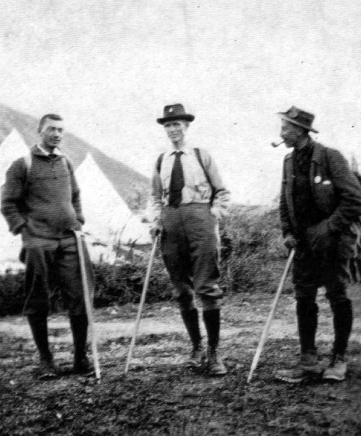
A.O. Wheeler, Donald “Curly” Phillips, Harry Blagden, Ned Hollister, Charles Walcott Jr., James Shand-Harvey, Casey Jones and Rev. George B. Kinney, near Maligne Lake, Smithsonian-ACC Robson Expedition
Photo: Byron Harmon, 1911
Whyte Museum of the Canadian Rockies

Donald Philips and his pack ponies.
Photo, Julia Wilcox, 1913
Canadian Alpine Journal 1915
Donald “Curly” Phillips [1884–1938]
b. 1884 — Dorset, Ontario, Canada
d. 1938 — Jasper, Alberta, Canada
Donald “Curly” Phillips [1884–1938] was a Jasper guide and outfitter who accompanied George R. B. Kinney [1872–1961] almost to the top of Mount Robson in 1909. Phillips spent his youth in the Lake of the Bays district of Ontario, where he became an expert woodsman and master of white water craft. He was a member of the Guide’s Association of Ontario.
He came to the Jasper region in 1909 to explore the country and start an outfitting and guiding business. He met George Kinney on the Athabasca River that year, when Kinney was looking for a partner to for his third attempt on Mount Robson. Although Phillips had no mountain climbing experience, he joined Kinney, and they made several ascents around the end of July, finally reaching, on Friday, August 13, what Kinney claimed was the peak. Phillips later stated that the highest point had not been reached.
“I found in Phillips a very prince of the trail,” wrote Kinney. “Quick, handy, a splendid cook and bubbling over with good nature, he made a camp-mate that could not be excelled. Never in all the hard days did he utter a word of discouragement, or falter in our undertaking, and though he had never climbed mountains before that summer, he proved to be a cool-headed and cautious climber. I have seldom seen his equal.”
Phillips catered and acted as guide to the 1911 Alpine Club of Canada–Smithsonian Robson Expedition organized by Arthur Oliver Wheeler [1860–1945], president of the Alpine Club of Canada. Wheeler described Phillips as a “superman” and “a mighty hunter,” “a skilled river-driver” who “can cross any kind of water on a single stick big enough to hold him.”
Phillips also catered for the Alpine Club of Canada’s 1913 camp, during which William Wasborough Foster [1875–1954], Albert H. McCarthy [1876–1956], and Conrad Kain [1883–1934] made the first indisputable ascent of Mount Robson. Phillips built a causeway along the edge of the Robson River gorge, beside White Falls and the Falls of the Pool, which gave hikers and horses access to Berg Lake from the railway.
He took Mary Lenore Jobe Akeley [1878–1966] on her exploratory trip to Mount Sir Alexander (which she called “Mount Kitchi”) in 1915 and later organized many canoe trips on the Peace and Mackenzie rivers. Phillips also catered for the second Mount Robson camp in 1924, for the Tonquin Valley camp in 1926, and for the Maligne Lake camp in 1930, when he was handling tourist motor boat transportation on Medicine and Maligne lakes. He became the most renowned tourist guide of the region.
Phillips died in an avalanche while skiing on the slopes of Elysium Mountain near Jasper. In a memoriam published in the 1937 Canadian Alpine Journal, Wheeler called him “A splendid specimen of manhood; fearless, always efficient, always full of resource, always even-tempered, he was the prefect guide in whom his patrons had the greatest confidence, and he will long be remembered in the annals of Jasper.”
Sources of biographical information about Phillips:
- Wheeler, Arthur Oliver [1860–1945]. “In Memorian: ‘Curly’ Phillips.” Canadian Alpine Journal, Vol. 25 (1937):117
- Thorington, James Monroe [1895–1989]. “Donald Phillips, 1884-1938.” American Alpine Journal, Vol 3, No. 3 (1939) American Alpine Club
- Hart, Edward John “Ted” [1946–]. Diamond hitch: the early outfitters and guides of Banff and Jasper. Banff: Summerthought, 1979
- Taylor, William C. Tracks across my trail. Donald “Curly” Phillips, guide and outfitter. Jasper: Jasper-Yellowhead Historical Society, 1984
- Scott, Chic. Pushing the Limits: The Story of Canadian Mountaineering
48 50 62
. Calgary: Rocky Mountain Books, 2000 Internet Archive
Phillips is the namesake of the following places in the Mount Robson region:
Events in the Mount Robson region in which Phillips was involved:
- 1906 ACC organized, Mount Robson attempt proposed
- 1909 Kinney and Phillips at Mount Robson
- 1911 ACC-Smithsonian Robson expedition (outfitter)
- 1912 Phillips builds trail to Berg Lake
- 1913 ACC Camp – Mount Robson (packer)
- 1914 Jobe-Phillips expedition Mt. Kitchi
- 1915 Jobe-Phillips to Kitchi
- 1915 Jobe’s second expedition to Mount Sir Alexander (guide)
- 1917 Jobe trip to Wapiti
Works pertinent to the Mount Robson region of which Phillips was author or co-author:
- — “To the top of Mount Robson.” Canadian Alpine Journal, Vol. 2, No. 2 (1910):21-44
- Kinney, George Rex Boyer [1872–1961], and — “To the top of Mount Robson.” Canadian Alpine Journal, Vol. 2, No. 2 (1910):21-44
- — “Fitzhugh to Laggan. Report by Donald Phillips to A. O. Wheeler, Director of the Alpine Club, Canada.” Canadian Alpine Journal, Vol. 4 (1912):83-86
- — “Winter conditions north and west of Mt. Robson.” Canadian Alpine Journal, Vol. 6 (1914–1915):128-135
- — “Athabaska Pass to Tonquin Valley via Goat and Fraser Rivers.” Canadian Alpine Journal, Vol. 13 (1923):153
- — Banff: M106/147 (1924).