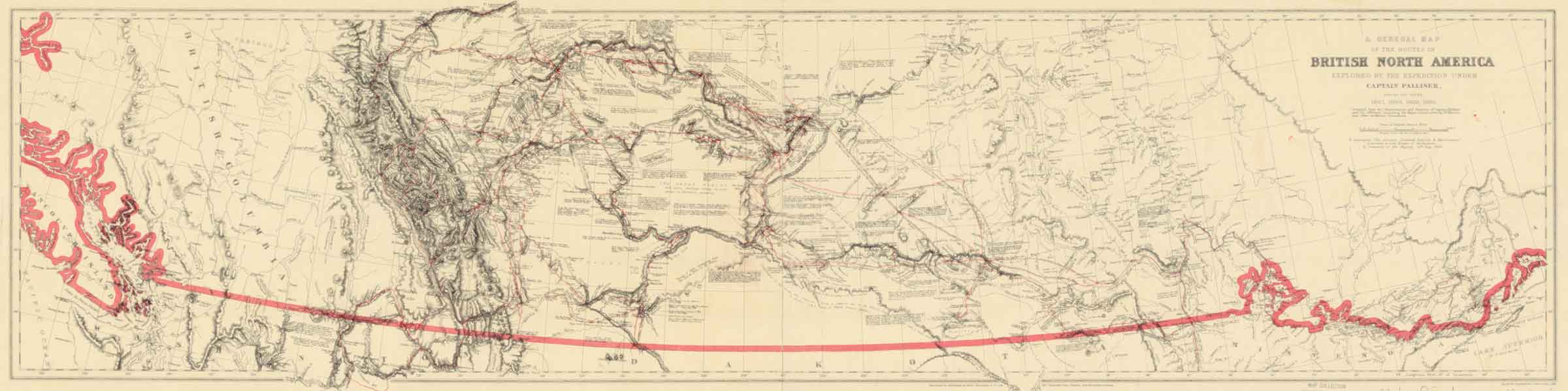
General map of the routes in British North America explored by the expedition under Captain Palliser during the years 1857, 1858, 1859, 1860 Internet Archive [accessed 26 February 2025]
![Palliiser’s routes [detail]](/wp-content/uploads/2025/02/pallliser-detail.jpg)
Palliiser’s routes [detail]
A General Map of the Routes in British North America Explored by the Expedition under Captain Palliser, during the years 1857, 1858, 1859, 1860. Compiled from the Observations and Reports of Captain Palliser and his Offcers, including the Maps constructed by Dr. Hector, and other authentic documents. To accompany “The Journals, Detailed Reports, & Observations” presented to both Houses of Parliament, by Command of Her Majesty, 19th May, 1863. Standord’s Geographical Estab. London, 1865
Captain John Palliser [1817–1887] was a geographer who hailed from County Meath, Ireland. After service in the military he participated in a hunting exploration among the native peoples of the American West that was chronicled in his book, Adventures of a Hunter in the Prairies, published to much acclaim in 1853.
Later that decade, the Royal Geographic Society proposed to the Colonial Office that Palliser explore Canadian territory between Lake Superior and the Rocky Mountains, which was approved by Secretary of State for the Colonies, Henry Labouchere. His instructions to Palliser was to attain a general and scientific knowledge of the regions in areas of land, agriculture, coal and minerals.
This map shows the routes taken by the British North America Exploring Expedition over its four year period. Despite a £13,000 budget that was three times the original estimate its findings provided the Government with invaluable evidence on the topographical and economic potential of the country.
Athabasca River
Bear River
Boat Encampment
Mount Brown
Brûlé Lake [as “Lac à Brulé”]
Caledonia Mountain
Canoe River
Mount Christie
Colin Range
Committee Punch Bowl
Columbia River
Cow Dung Lake
Cranberry Lake
Cranberry River
Fiddle Mountains
Fraser River
Grand Côte
Henry House [as “Miette or Henry Ho.”]
Mount Hooker
Jasper House
Jasper
Mount Kerkeslin
Leather Pass
Mount Lyell
Maligne River
Miette River
Mount Moberly
Moose Lake
North Thompson River [as “Thompson R. (N. Branch)”]
Lac Orignal
Pyramid Mountain
Rau’ Shuswap
Roche Miette
Roche Suette
Roche Jacques [as “Roche Jacque”]
Selkirk Mountains
Smoky River [as “Smoking R.”]
Snake Indian River
Snaring River
Mount Tekarra
Tête Jaune Cache [as “Yellow Head”]
Whirlpool River
Wood River [as “Woods Pt.”]
Tribes
Beaver Indians [“Beaver and Chickanee Indians”]
Chickanee Indians
Iroquois Indians
Sekani Indians [as “Beaver and Chickanee Indians”]
- Palliser, John [1817–1887]. Solitary Rambles and Adventures of a Hunter in the Prairies. London: John Murray, 1853. Internet Archive [accessed 27 February 2025]
- Palliser, John [1817–1887]. Further Papers Relative to the Exploration by the Expedition Under Captain Palliser of That Portion of British North America Which Lies Betwees the Northern Branch of the River Saskatchewan and the Frontier of the United States; And Between the Red River and the Rocky Mountains, and Thence to the Pacific Ocean.. London: George Edward Byre and William Spottiswoode, 1860. Canadiana [accessed 10 March 2025]
- Spry, Irene Mary Biss [1907–1998], editor. The Papers of The Palliser Expedition 1857-1860. Champlain Society, 1968. Internet Archive [accessed 26 February 2025]