Tag Archives: Indigenous

Kakwa River

British Columbia and Alberta. River: Smoky River drainage
Flows NE across BC-Alberta boundary into Smoky River, E of Jarvis Lakes
54.0997 N 120.0011 W — Map 93I/1 — GoogleGeoHack
Name officially adopted in 1925
Official in BCCanada

Name appears on BC-Alberta Boundary Atlas sheet No. 39, 1924. The river was labeled “Porcupine River” on 1912 map of BC Northern Interior (publisher not cited), and on BC Lands 1913 Preliminary Forest Map, and on BC Lands 1917 map of the Forest Stand Types in British Columbia.

Explorer Samuel Prescott Fay [1884–1971], who spent the summers of 1912 to 1914 tracking big game in this area, suggested that the name “Porcupine” be changed [or revert (?)] to “Kakwa”, the Cree word for porcupine.

“Kakwa” is listed at the Indigenous Geographical Names dataset as a word of Cree language.

References:

  • Fay, Samuel Prescott [1884–1971]. “Mount Alexander.” Canadian Alpine Journal, Vol. 6 (1914–1915):121
  • Fay, Samuel Prescott [1884–1971]. “Note on Mount Alexander Mackenzie and Mount Ida.” Alpine Journal, Vol. 36 (1924):421, p.55
  • Andrews, Gerald Smedley [1903–2005]. Métis outpost. Memoirs of the first schoolmaster at the Métis settlement of Kelly Lake, B.C. 1923-1925. Victoria: G.S. Andrews, 1985. Internet Archive
  • British Columbia Geographical Names. Kakwa River

Shuswap River

British Columbia. Former name: Fraser River drainage
Former name for Raush River
53.2 N 120 W GoogleGeoHack
Not currently an official name.
This former name appears on:
Trutch’s map of BC 1871 [as “Rau’ Shuswap”]
BC Lands Central BC 1892 [as “Rau Shuswap R.”]
Collie’s map Yellowhead Pass 1912
The river now known as the Raush River appears as “Rau’ Shuswap” on Trutch’s map of BC from 1871 and as “Big Shuswap R.” on the 1912 map of John Norman Collie [1859–1942]. Shuswap (Secwépemc) people lived in the area when Europeans showed up.

In 1863 Milton and Cheadle encountered Shuswap people at Jasper House and Tête Jaune Cache. “The Shushwaps of Jasper House formerly numbered about thirty families, but are now reduced to as many individuals,” they wrote. [1]

The Texqakallt band of the upper North Thompson River were the earliest known inhabitants of the upper reaches of the Fraser River. They were almost completely nomadic. Lodges and fish drying racks were constructed in prime salmon fishing territory at the confluence of the McLennan River and Fraser Rivers in the vicinity of what is now Tête Jaune Cache. As well as salmon from the Fraser, trout were reportedly taken from Yellowhead Lake. They hunted bighorn sheep, mountain goats, moose, marmots, and other small mammals and birds. They also relied on edible plants in the area, especially berries.[2]

References:

  • 1. Milton, William Wentworth Fitzwilliam [1839–1877], and Cheadle, Walter Butler [1835–1910]. The North-West Passage by Land. Being the narrative of an expedition from the Atlantic to the Pacific, undertaken with the view of exploring a route across the continent to British Columbia through British territory, by one of the northern passes in the Rocky Mountains. London: Cassell, Petter and Galpin, 1865, p. 240. Internet Archive
  • 2. Wikipedia. Texqakallt

Little Shuswap Creek

British Columbia. creek: Fraser River drainage
Former name for Kiwa Creek
53.0217 N 119.5636 W GoogleGeoHack
Not currently an official name.

In his “Notes on the Cariboo Range” of 1925, Munday wrote, “The local name of the Big Shuswap conflicts with the Shuswap River further south and appears on recent government maps as Raushwap or Rausch River (from Riviere au Shuswap). Kiwa Creek is known locally as Little Shuswap.”

References:

  • Munday, Walter Alfred Don [1890–1950]. “In the Cariboo Range – Mt. David Thompson.” Canadian Alpine Journal, Vol. 15 (1925):130-136
Also see:

Kinbasket Lake

British Columbia. Lake: Columbia River drainage
Expansion of Columbia River behind Mica Dam
52.1333 N 118.45 W — Map 83D/1 — GoogleGeoHack
Earliest known reference to this name is 1866 (Moberly)
Official in BCTopo map from Canadian Geographical Names
This lake appears on:
Brownlee’s map Province of BC 1893
Kinbasket Lake is indicated on John Arrowsmith’s map BC 1859 but not named.
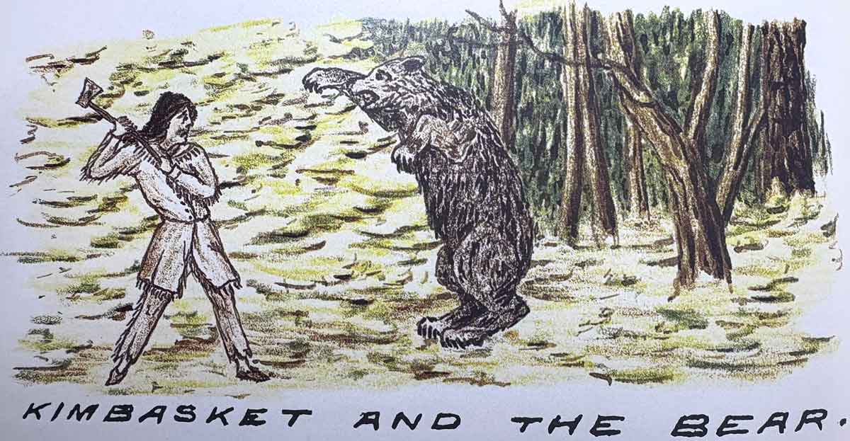
Kimbasket and the Bear

Kimbasket and the Bear
Rylatt, Surveying the Canadian Pacific, 1872, p. 86

Kinbasket Lake is named for a chieftain of the Shuswap (Secwépemc) people who inhabited the valleys of the upper Columbia River and upper North Thompson River. Walter Moberly [1832–1915] met Kinbasket, whom he referred to as “Kinbaskit,” in 1866.

We crossed the Columbia river, and at a short distance came to a little camp of Shuswap Indians, where I met their headman, Kinbaskit. I now negotiated with him for two little canoes made of the bark of the spruce, and for his assistance to take me down the river. Kinbaskit was a very good Indian, and I found him always reliable. We ran many rapids and portaged others, then came to a Lake which I named Kinbaskit Lake, much to the old chief’s delight. (1)

In 1872, they met again when Kinbasket guided a survey party for the Canadian Pacific Railway near Howse Pass. Robert M. Rylatt [fl. mid-1800s], a member of the party, referred to him as “Kimbasket.” Rylatt wrote in his memoirs:

On Saturday I had another Indian visitor, Old Kimbasket, the head chief of the Kootenay Indians, a daring, little shriveled up old fellow, but whom I was glad to see, and with whom I suddenly became acquainted with the Chinook jargon again.… This old chief Kimbasket is in the employ at present, and his principal occupation is blazing; that is to say, his duty is to be in advance of the party, and blaze the best route to be followed in making the trail, by blazing trees within sight of each other; or, should this not be clearly understood, blazing signifies chipping the bark off the trees for about a foot, so as to be clearly desernable to the party following.…

Seven miles beyond here the [Columbia] river opens up into a lake, which has been named after the old chief “Kimbasket Lake.” This lake is some 20 miles in length, and using the boats over this surface would be a great saving of time and labor, and would rest the animals considerably. [p. 76]

Tuesday, Augt 20th [1872] Poor old Chief Kimbasket has come to grief. He was in his place a day or two ago, or in other words was somewhat in advance of the party blazing the route, when of a sudden he was set upon by a bear, and having no arms save his light axe, his bearship took him at advantage; the rush to the attack was so sudden, and the animal apparantly so furious, the old chief had barely time to raise the axe and aim a blow as the brute raired, ’ere his weapon was dashed aside like a flash, and he was in the embrace of the monster, the huge forepaws around him, the immense claws dug into his back, the bear held him up; then fastening the poor chiefs shoulder in his iron Jaws, he raised one of his hind feet, and tore a fearful gash; commencing at the abdomen, and cutting through to the bowels, he fairly stripped the flesh and muscles from one of his thighs, a bloody hanging mass of flesh and rent cloth-ing. Thus he was found the following morning, being too weak and torn to attempt to reach camp. What a night of suffering he must have had. Green, who by the way has studied medicine, and is considerable of a doctor, says he hopes to bring him round all right, but that he has had a narrow squeek for it. As soon as he can travel, he will be sent off with the Indians who will shortly be leaving us. [p. 85]

It was on the shores of this lake Kimbasket was so fearfully mangled, it remains a mystery to me why the brute did not quite finish the poor chief ‘ere leaving him. [p. 91] (2)

Moberly also describes the bear attrack:

Kinbaskit and the two Indians soon returned with the bear, but poor Kinbaskit was rather badly wounded, which occurred, as the Indians toldme, in the following way. They traced the wounded animal by the blood,and found him lying alongside a log. Kinbaskit thought he was so badlywounded he could do no harm, and advanced with only a heavy stick in hishand to despatch him; but when, quite close the bear suddenly stood upon his hind legs and struck Kinbaskit with one of his paws, giving himsevere wounds on the scalp and tearing the flesh of his arm and hand very badly, when the Indian, Tim, shot the bear dead. It was quite a surgical work, sewing and plastering up the old chiefs wounds, who appeared quite unconcerned.

The lake was noted by David Thompson [1770–1857]:

April 19th. [1811] We proceeded five miles of strong rapids, in places we had to carry the cargo, such as it was, to where the River expanded to a small Lake which was frozen over, and we had to camp, we anxiously wished to clear away the snow to the ground ; but found it five and a half feet deep, and were obliged to put up with a fire on logs and sit on the snow. (3)

The original lake was engulfed by the flooding of the Columbia River valley after the Mica Dam was cvompleted in 1973. Kinbasket Lake is now a 260-kilometer long hydropower reservoir. From 1973 to 1980 the reservoir was called McNaughton Lake, after General Andrew McNaughton. The former name still appears on many maps.

“Kinbasket Lake” is listed in the Indigenous Geographical Names dataset as a word of the Shuswap language.
References:

  • 1. Moberly, Walter, C.E. [1832–1915]. The Rocks and Rivers of British Columbia. London: Blacklock, 1885. Faded Page
  • 2. Rylatt, Robert M. [fl. mid-1800s]. Surveying the Canadian Pacific: Memoir of a Railroad Pioneer. Salt Lake City: University of Utah Press, 1991
  • 3. Thompson, David [1770–1857]. David Thompson’s Narrative of his explorations in western America, 1784-1812. Joseph Burr Tyrrell, editor. Toronto: Champlain Society, 1916. University of British Columbia

Chushina Ridge

Alberta-BC boundary. Ridge
Between Snowbird Pass and Lynx Mountain
53.1342 N 119.0486 W — Map 083E03 — GoogleGeoHack
Earliest known reference to this name is 1912 (Walcott)
Name officially adopted in 1924
Official in BCCanada

“Chushina” is a Stoney word signifying “small” and was thought to be descriptive of this ridge when members of a 1911 Alpine Club of Canada–Smithsonian Robson Expedition named this feature.

[From the crest of Phillips Mountain] a glacier slopes down for a mile and a half to the edge of the cliffs west of Snowbird Pass. It is such a fine example of a small and complete glacier from névé to foot that I think it worthy of the name Chushina.

Charles Doolittle Walcott [1850–1927]

Walcott applied his name to the glacier, but now it applies to the ridge.

“Chushina Ridge” is listed at Indigenous Geographical Names dataset as a word of undetermined language.

References:

  • Walcott, Charles Doolittle [1850–1927]. “The monarch of the Canadian Rockies.” National Geographic Magazine, (1913):626. Internet Archive
  • British Columbia Geographical Names. Chushina Ridge

Cariboo Mountains

British Columbia. Mountains
Between Rocky Mountain Trench and E side of Bowron Lake
52.9167 N 120.25 W — Map 93A/16 — GoogleGeoHack
Earliest known reference to this name is 1861 (James Douglas)
Name officially adopted in 1918
Official in BCCanada
Cariboo Mountains

Cariboo Mountains

The name “Cariboo” is derived from an Algonquian word xalibu, meaning “pawer” or “scratcher,” referring to the North American reindeer. The name was first applied to the goldfield area around Quesnel and Barkerville, where caribou were once abundant. The name goes back to at least 1861, near the beginning of the gold rush, when governor James Douglas [1803–1877] of the colony of British Columbia used the name “Cariboo” to describe the area in dispatches to Britain.

Raymond T. Zillmer made a number of explorations in the Cariboo Mountains in the 1930s and 40s and wrote articles about area in the Canadian Alpine Journal and the American Alpine Journal.

The Cariboo Range is important in the development of Canada. When the Canadian Pacific Railway considered the matter of its route across the continental divide, it tentatively selected Yellowhead Pass, for it offered the easiest crossing. But that decision was frustrated by the Cariboo Mountains. A practical railroad route led from Yellowhead Pass to the Fraser River and down the Fraser until the Cariboo Range was reached, about 50 miles west of the pass. Here, from an elevation of 2400 ft., at Tête Jaune Cache, the Cariboo Range rises in a very short distance to as high as 11,750 ft., the height of Mt. Sir Wilfred Laurier, the highest peak of the entire Interior Ranges of British Columbia. If a route could not be found across the range, a long detour to the northwest or to the south was necessary—the routes now followed by the Canadian National Railway. So from 1871 to 1874 four well- equipped expeditions sought a route across the Cariboo Mountains. But they found that only high glacial passes were available. So the route across Yellowhead Pass was abandoned in favor of the more southerly route now used by the Canadian Pacific Railway.

— Zillmer 1939

The name “Cariboo Mountains” was officially adopted in 1918, not “Cariboo Range” as labelled on Bowman’s 1887 map of the Cariboo Mining District.

References:

  • Holway, Edward Willet Dorland [1853–1923]. “The Cariboo Mountains.” Canadian Alpine Journal, 8 (1917):36-39
  • Trutch, Joseph William [1826–1904]. Map of British Columbia to the 56th Parallel North Latitude. Victoria, B.C.: Lands and Works Office, 1871. University of Victoria
  • Bowman, Amos B. [1839–1894]. Maps of the principal auriferous creeks in the Cariboo mining district, British Columbia. Ottawa: Geological Survey of Canada, 1895. Hathi Trust
  • Bowman, Amos B. [1839–1894]. Map of the Cariboo Mining District, British Columbia, to illustrate the report of Amos Bowman. 1895. Cariboo Gold Rush
  • Zillmer, Raymond T. [1887–1960]. “Explorations in the Southern Cariboos.” Canadian Alpine Journal, Vol. 27 (1939):48-61
  • Zillmer, Raymond T. [1887–1960]. “The exploration of the Cariboo Range from the east.” American Alpine Journal, 5:2 (1944):261-274. American Alpine Club
  • Thorington, James Monroe [1895–1989]. “Canada, Cariboo Range.” American Alpine Journal, Vol. 7, No. 2 (1949). American Alpine Club
  • Akrigg, Helen B., and Akrigg, George Philip Vernon [1913–2001]. British Columbia Place Names. Vancouver: UBC Press, 1997. Internet Archive
  • British Columbia Geographical Names. Cariboo Mountains